154 countries
(and areas)
 - Azerbaijan
- Bahrain
- Barbados
- Belgium
- Belize
- Benin
- Bhutan
- Bolivia
- Bonaire
- Bosnia and Herzegovina
- Botswana
- Brazil
- British Virgin Islands
- Brunei
- Bulgaria
- Cambodia
- Canada
- Cape Verde
- Chile
- China
- Costa Rica
- Croatia
- Cuba
- Curacao
- Cyprus
- Czech Republic
- Denmark
- Dominica
- Dominican Republic
- Egypt
- El Salvador
- England
- Estonia
- Eswatini (Swaziland)
- Ethiopia
- Fiji
- Finland
- France
- French Guiana
- Georgia
- Germany
- Gibraltar
- Greece
- Grenada
- Guadeloupe
- Guatemala
- Honduras
- Hong Kong
- Hungary
- Iceland
- India
- Indonesia
- Iran
- Ireland
- Israel
- Italy
- Jamaica
- Japan
- Jordan
- Kazakhstan
- Kenya
- Kosovo
- Kuwait
- Kyrgyzstan
- Laos
- Latvia
- Lebanon
- Lesotho
- Liechtenstein
- Lithuania
- Luxembourg
- Macau
- Madagascar
- Malawi
- Malaysia
- Maldives
- Malta
- Martinique
- Mexico
- Moldova
- Monaco
- Mongolia
- Montenegro
- Morocco
- Mozambique
- Namibia
- Nepal
- Netherlands
- New Zealand
- Nicaragua
- North Macedonia
- Northern Ireland
- Norway
- Oman
- Pakistan
- Palestine
- Peru
- Philippines
- Poland
- Portugal
- Qatar
- Republic of Korea
- Romania
- Russia
- Saint Kitts and Nevis
- Saint Lucia
- Saint Martin
- Saint Vincent and the Grenadines
- San Marino
- São Tomé and Principe
- Saudi Arabia
- Scotland
- Senegal
- Serbia
- Singapore
- Sint Maarten
- Slovakia
- Slovenia
- South Africa
- Spain
- Sri Lanka
- Suriname
- Sweden
- Switzerland
- Tajikistan
- Tanzania
- Thailand
- The Gambia
- Tibet
- Togo
- Transnistria
- Trinidad and Tobago
- Tunisia
- Turkey
- Turkmenistan
- Uganda
- United Arab Emirates
- United States
- Uruguay
- Uzbekistan
- Vatican City
- Vietnam
- Wales
- Zambia
- Zanzibar
- Azerbaijan
- Bahrain
- Barbados
- Belgium
- Belize
- Benin
- Bhutan
- Bolivia
- Bonaire
- Bosnia and Herzegovina
- Botswana
- Brazil
- British Virgin Islands
- Brunei
- Bulgaria
- Cambodia
- Canada
- Cape Verde
- Chile
- China
- Costa Rica
- Croatia
- Cuba
- Curacao
- Cyprus
- Czech Republic
- Denmark
- Dominica
- Dominican Republic
- Egypt
- El Salvador
- England
- Estonia
- Eswatini (Swaziland)
- Ethiopia
- Fiji
- Finland
- France
- French Guiana
- Georgia
- Germany
- Gibraltar
- Greece
- Grenada
- Guadeloupe
- Guatemala
- Honduras
- Hong Kong
- Hungary
- Iceland
- India
- Indonesia
- Iran
- Ireland
- Israel
- Italy
- Jamaica
- Japan
- Jordan
- Kazakhstan
- Kenya
- Kosovo
- Kuwait
- Kyrgyzstan
- Laos
- Latvia
- Lebanon
- Lesotho
- Liechtenstein
- Lithuania
- Luxembourg
- Macau
- Madagascar
- Malawi
- Malaysia
- Maldives
- Malta
- Martinique
- Mexico
- Moldova
- Monaco
- Mongolia
- Montenegro
- Morocco
- Mozambique
- Namibia
- Nepal
- Netherlands
- New Zealand
- Nicaragua
- North Macedonia
- Northern Ireland
- Norway
- Oman
- Pakistan
- Palestine
- Peru
- Philippines
- Poland
- Portugal
- Qatar
- Republic of Korea
- Romania
- Russia
- Saint Kitts and Nevis
- Saint Lucia
- Saint Martin
- Saint Vincent and the Grenadines
- San Marino
- São Tomé and Principe
- Saudi Arabia
- Scotland
- Senegal
- Serbia
- Singapore
- Sint Maarten
- Slovakia
- Slovenia
- South Africa
- Spain
- Sri Lanka
- Suriname
- Sweden
- Switzerland
- Tajikistan
- Tanzania
- Thailand
- The Gambia
- Tibet
- Togo
- Transnistria
- Trinidad and Tobago
- Tunisia
- Turkey
- Turkmenistan
- Uganda
- United Arab Emirates
- United States
- Uruguay
- Uzbekistan
- Vatican City
- Vietnam
- Wales
- Zambia
- Zanzibar


Copyright 2004 - 2026
Veeronline.nl Travel Adventures

Home > Iceland > Volcanoes Glaciers and Waterfalls > Travelogue day 10
Travelogue Volcanoes Glaciers and Waterfalls
August 113 2021 (13 days)
Iceland > Behind the Seljalandsfoss
Dag 10 - Tuesday 10 August 2021At eight o’clock, breakfast is ready. The man who came into our room last night prepared the buffet. He greets us kindly. No idea if he connects us to the incident. After breakfast, we drive along the glaciers one last time. The mist from last night has lifted, and the sun is shining again. We’ve been lucky with the weather the last few days. We continue driving to Kirkjubæjarklaustur. This village lies beyond Jökulsárlón, the iceberg lagoon, and Skaftafell National Park. We drive nearly two hundred kilometers. Just past Kirkjubæjarklaustur is the Fjaðrárgljúfur Canyon. A particularly beautifully carved canyon. Until recently, the canyon was almost unknown, until Justin Bieber shot a videoclip here. Not only fans of the Canadian singer come here now, but since then, the Fjaðrárgljúfur Canyon has also been listed in most travel guides. We follow a line of cars from the ring road exit to the parking lot. The parking lot is practically full, making it look very busy. Yet there might only be about fifty cars and one coach. Due to the huge influx of tourists, walking through the canyon itself is no longer allowed. Only the path along the top edge of the canyon is accessible. From several viewing platforms, we have a view into the beautiful canyon.

What beautiful nature. From the last viewing platform, you can also see the waterfall. The water falls in stages about a hundred meters down from the canyon’s edge. From the canyon, it’s still sixty kilometers to Vík. The ring road runs through the vast Eldhraun lava fields. This lava field was created in 1783 during an eruption of the Lakagígar volcano. The eruption lasted a staggering nine months and was one of the most severe in Iceland. The solidified lava rock has since been covered with moss. The moss on the lava is fragile and grows extremely slowly. That is why in Iceland it is everywhere requested not to step on the moss. Recovery can take decades. The town of Vík í Mýrdal, which means ‘bay in the bog valley,’ lies in a sheltered spot by the sea. It is the southernmost town in Iceland. It is also the place where most rain falls. Luckily, it is dry today. In the old center of Vík, we order lunch in a restaurant. There are hardly any dining options near our accommodation tonight. By eating well now, we can have a picnic tonight. The nearby visitor center doesn’t impress us much. We drive back to the main road to refuel and do some shopping. Just outside Vík is the Dyrhólaey bird rock. Previously, you could drive up close to the lighthouse, but because of the increased number of tourists, a new parking lot has been built.

From there, it’s a half-hour walk to the lighthouse. A strong, chilly wind accompanies us. Over the rocky path, we walk up to the base of the lighthouse. The Dyrhólaey rock has two arches where the seawater flows through. From the high rocky point, we have a wonderful view of this. On the way back to the parking lot, we see many people gathered. There turn out to be puffins sitting on the rocks. The birds fly out to search for food. Landing on the rocks in the strong wind is not easy for every puffin. Some young birds simply let themselves fall the last bit. A little further along the ring road near the village of Skógar lies Skógafoss. We can see the waterfall from the road. The water crashes violently over the edge. The waterfall is 25 meters wide and 60 meters high. Although we have already seen several waterfalls on this trip, this one is special again. Via stairs on the side, we climb to the top of the waterfall. The first steps are very high. Each step is certainly over thirty centimeters. Luckily, after that, there is a metal staircase with normal steps. From the top, we look right at the edge of the waterfall and the river that feeds the water. In the depth below, we see a campsite and the parking lot. Everything looks very small from this height.

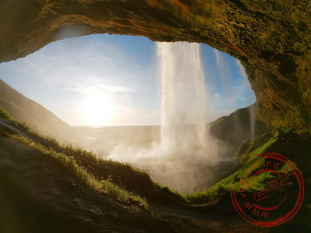
It is now six o’clock. We drive the last bit to our accommodation. The navigation system does not know the village. We enter the coordinates of the accommodation address. A little later, we drive onto the grounds of Brú guesthouses. In the middle of a plain stand twelve modern bungalows. They look like twelve big boxes. From our cottage, we look out over farmland and the mountains behind it. In the evening, we plan to go to the Seljalandsfoss waterfall, which is nearby. Because we ate extensively this afternoon, we take a picnic with some bread, toppings, and juice. The special thing about the Seljalandsfoss waterfall is that you can walk behind the water. Together with the sunset, this should be an idyllic place to eat. The idea was good, but the execution less so. There is a strong wind at the waterfall, and the splashing water makes the surroundings wet. Carefully, we walk along the narrow path behind the waterfall. The low sun shines through the water spray. The sun lights up the falling water. It is a beautiful sight. We abandon the picnic plan. We take the things back to our cottage and eat there.
 Iceland
  The water of the lfusa River falls at Gullfoss
 In summer whales swim around the bay of Husavik
 The Otto Matur Drykkur restaurant in Hofn
 Icebergs can be viewed up close
Travelogue Volcanoes Glaciers and Waterfalls
Dag 2 | Iceland > The Snæfellsnes Peninsula
Dag 3 | Iceland > The Hraunfossar Lava Waterfall
Dag 4 | Iceland > Bubbling Mud
Dag 5 | Iceland > Whale Safari at Sea
Dag 6 | Iceland > The Impressive Dettifoss
Dag 7 | Iceland > The 128-meter-high Hengifoss
Dag 8 | Iceland > Sailing among the Icebergs
Dag 9 | Iceland > Hiking on the Glacier
Dag 10 | Iceland > Behind the Seljalandsfoss
Dag 11 | Iceland > Colorful Landmannalaugar
Dag 12 | Iceland > The Golden Circle
Dag 13 | Iceland > To Keflavík