154 countries
(and areas)
 - Azerbaijan
- Bahrain
- Barbados
- Belgium
- Belize
- Benin
- Bhutan
- Bolivia
- Bonaire
- Bosnia and Herzegovina
- Botswana
- Brazil
- British Virgin Islands
- Brunei
- Bulgaria
- Cambodia
- Canada
- Cape Verde
- Chile
- China
- Costa Rica
- Croatia
- Cuba
- Curacao
- Cyprus
- Czech Republic
- Denmark
- Dominica
- Dominican Republic
- Egypt
- El Salvador
- England
- Estonia
- Eswatini (Swaziland)
- Ethiopia
- Fiji
- Finland
- France
- French Guiana
- Georgia
- Germany
- Gibraltar
- Greece
- Grenada
- Guadeloupe
- Guatemala
- Honduras
- Hong Kong
- Hungary
- Iceland
- India
- Indonesia
- Iran
- Ireland
- Israel
- Italy
- Jamaica
- Japan
- Jordan
- Kazakhstan
- Kenya
- Kosovo
- Kuwait
- Kyrgyzstan
- Laos
- Latvia
- Lebanon
- Lesotho
- Liechtenstein
- Lithuania
- Luxembourg
- Macau
- Madagascar
- Malawi
- Malaysia
- Maldives
- Malta
- Martinique
- Mexico
- Moldova
- Monaco
- Mongolia
- Montenegro
- Morocco
- Mozambique
- Namibia
- Nepal
- Netherlands
- New Zealand
- Nicaragua
- North Macedonia
- Northern Ireland
- Norway
- Oman
- Pakistan
- Palestine
- Peru
- Philippines
- Poland
- Portugal
- Qatar
- Republic of Korea
- Romania
- Russia
- Saint Kitts and Nevis
- Saint Lucia
- Saint Martin
- Saint Vincent and the Grenadines
- San Marino
- São Tomé and Principe
- Saudi Arabia
- Scotland
- Senegal
- Serbia
- Singapore
- Sint Maarten
- Slovakia
- Slovenia
- South Africa
- Spain
- Sri Lanka
- Suriname
- Sweden
- Switzerland
- Tajikistan
- Tanzania
- Thailand
- The Gambia
- Tibet
- Togo
- Transnistria
- Trinidad and Tobago
- Tunisia
- Turkey
- Turkmenistan
- Uganda
- United Arab Emirates
- United States
- Uruguay
- Uzbekistan
- Vatican City
- Vietnam
- Wales
- Zambia
- Zanzibar
- Azerbaijan
- Bahrain
- Barbados
- Belgium
- Belize
- Benin
- Bhutan
- Bolivia
- Bonaire
- Bosnia and Herzegovina
- Botswana
- Brazil
- British Virgin Islands
- Brunei
- Bulgaria
- Cambodia
- Canada
- Cape Verde
- Chile
- China
- Costa Rica
- Croatia
- Cuba
- Curacao
- Cyprus
- Czech Republic
- Denmark
- Dominica
- Dominican Republic
- Egypt
- El Salvador
- England
- Estonia
- Eswatini (Swaziland)
- Ethiopia
- Fiji
- Finland
- France
- French Guiana
- Georgia
- Germany
- Gibraltar
- Greece
- Grenada
- Guadeloupe
- Guatemala
- Honduras
- Hong Kong
- Hungary
- Iceland
- India
- Indonesia
- Iran
- Ireland
- Israel
- Italy
- Jamaica
- Japan
- Jordan
- Kazakhstan
- Kenya
- Kosovo
- Kuwait
- Kyrgyzstan
- Laos
- Latvia
- Lebanon
- Lesotho
- Liechtenstein
- Lithuania
- Luxembourg
- Macau
- Madagascar
- Malawi
- Malaysia
- Maldives
- Malta
- Martinique
- Mexico
- Moldova
- Monaco
- Mongolia
- Montenegro
- Morocco
- Mozambique
- Namibia
- Nepal
- Netherlands
- New Zealand
- Nicaragua
- North Macedonia
- Northern Ireland
- Norway
- Oman
- Pakistan
- Palestine
- Peru
- Philippines
- Poland
- Portugal
- Qatar
- Republic of Korea
- Romania
- Russia
- Saint Kitts and Nevis
- Saint Lucia
- Saint Martin
- Saint Vincent and the Grenadines
- San Marino
- São Tomé and Principe
- Saudi Arabia
- Scotland
- Senegal
- Serbia
- Singapore
- Sint Maarten
- Slovakia
- Slovenia
- South Africa
- Spain
- Sri Lanka
- Suriname
- Sweden
- Switzerland
- Tajikistan
- Tanzania
- Thailand
- The Gambia
- Tibet
- Togo
- Transnistria
- Trinidad and Tobago
- Tunisia
- Turkey
- Turkmenistan
- Uganda
- United Arab Emirates
- United States
- Uruguay
- Uzbekistan
- Vatican City
- Vietnam
- Wales
- Zambia
- Zanzibar


Copyright 2004 - 2026
Veeronline.nl Travel Adventures
Home > Estonia > Baltic States > Travelogue day 8
Travelogue Baltic States
July 24 August 7 2010 (15 days)
Estonia > The bunkers of Sõrve
Dag 8 - Saturday, July 31, 2010We leave Kuressaare for a trip across the 32-kilometer-long Sõrve Peninsula, located just south of Kuressaare. The narrow peninsula is now a nature reserve.

During the Second World War, this narrow strip of land saw heavy fighting between German and Russian troops. Jouzas has never done this trip before and relies on Karen’s directions when she tells him to take a gravel road onto the peninsula. The road is dry and easy to drive on. At the bay, we take a short walk along the Baltic Sea, and a little farther on, the bus picks us up again. A bit further ahead, we see a small trail marker indicating a walking path. We follow it toward the water, but soon the trail runs parallel to the road. The farther we go, the harder the path becomes to follow. When we can no longer tell the difference between the trail and the surrounding forest, we decide to cut straight through the woods back to the road. It’s clear that few people walk here. My travel guide mentions old Soviet bunkers on this peninsula. Neither Juozaf nor Karen knows about them, but Juozaf steers the bus onto a narrow forest track at a sign pointing to the bunkers. Overgrown by vegetation, we find an old bunker complex — a large mound and a watchtower. Even after the Second World War, the island of Saaremaa remained heavily fortified by the Russians. Missiles were stationed here, aimed westward. The Sõrve Peninsula lies in a strategic position on the northern side of the Gulf of Riga. Today, all the bunkers are abandoned. Karen spots an opening among the bushes leading into one of the bunkers. With a small flashlight, we enter the dark corridor. Using the faint light, we check for pits or snakes on the ground. About twelve meters inside, the passage turns. We can make out small doorways — perhaps for heating or storage. When I take a photo in the dark, the flash reveals a steel door right in front of us. It’s open, and behind it lies an even larger bunker complex.

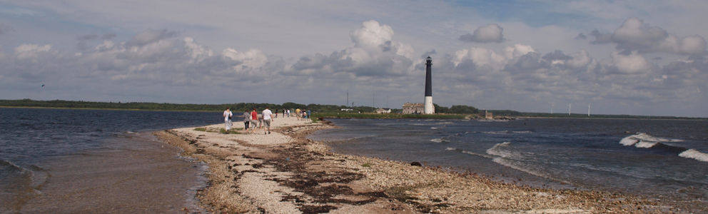
Because the floor there is covered with water and we can’t see where we’re stepping, we decide not to go any farther. We climb out on the other side. As we continue driving, we see more bunkers scattered to the left and right. At the very tip of the peninsula stands the tall black lighthouse of Sõrve. This striking dark tower marks the entrance to the Gulf of Riga for ships. We walk past the lighthouse along the narrow spit of land to the very end. The strip is barely five meters wide, and the wind has full force here — no wonder kite-surfers are out in numbers. Waves from both the Gulf of Riga and the Baltic Sea crash ashore, meeting right at the point. With the wind at our backs, we walk back to the bus. We return to Kuressaare via the other coastline. At the border between the peninsula and the island of Saaremaa, we stop at a World War II memorial. It was here, in 1944, that opposing troops clashed, and many men lost their lives. At two o’clock we drive back into Kuressaare. We get off the bus at the castle. The castle of Kuressaare has been renovated and now houses a museum. Unfortunately, restoration work is still underway on the main tower, so it’s closed to visitors. As a result, we also can’t walk along the ramparts — something said to be quite special. Perhaps because of that, the castle feels a bit disappointing. From the defensive wall, we return to Lossi, Kuressaare’s main street. We follow the city walk from the travel guide, but in reverse order. We pass beautiful neoclassical residences, the Russian Orthodox St. Nicholas Church, and the old Town Hall (built in 1670) along with the historic Weigh House — two of the city’s oldest buildings. In the evening, we dine in the center and end the day at the fairground next to the hotel. Later, in the hotel’s common room, we have one last beer as a nightcap.
 Russia
  The busy Griboedov Canal with the Church of the Savior on Blood in the background
 LR Pieter Rob Marian Christine Bep Paul Maren Dikkie Marion Petra Leo Alie Erik Rita Kristel Marijke Jenny Karen Ronald Nicolette Nele Betsie Roelof
 Estonia
  The lighthouse at Saare on the far tip of Saaremaa
 The throne in St George Hall in the Hermitage Saint Petersburg
Travelogue Baltic States
Dag 2 | Lithuania > Wandering among the churches
Dag 3 | Lithuania > At the Water Castle of Trakai
Dag 4 | Lithuania > By bike over the Curonian Spit
Dag 5 | Latvia > Crosses, crosses and more crosses
Dag 6 | Latvia > Riga, the beating heart of the Baltics
Dag 7 | Estonia > The sturdy fortress church of Pölde
Dag 8 | Estonia > The bunkers of Sõrve
Dag 9 | Estonia > The Middle Ages in Tallinn
Dag 10 | Estonia > Searching for Kodak points in Tallinn
Dag 11 | Estonia > In the catacombs under old Tallinn
Dag 12 | Russia > Crossing the Russian border
Dag 13 | Russia > Hermitage and the Swan Lake
Dag 14 | Russia > Wandering through Saint Petersburg
Dag 15 | Russia > Visit to the Catherine Palace