154 countries
(and areas)
 - Azerbaijan
- Bahrain
- Barbados
- Belgium
- Belize
- Benin
- Bhutan
- Bolivia
- Bonaire
- Bosnia and Herzegovina
- Botswana
- Brazil
- British Virgin Islands
- Brunei
- Bulgaria
- Cambodia
- Canada
- Cape Verde
- Chile
- China
- Costa Rica
- Croatia
- Cuba
- Curacao
- Cyprus
- Czech Republic
- Denmark
- Dominica
- Dominican Republic
- Egypt
- El Salvador
- England
- Estonia
- Eswatini (Swaziland)
- Ethiopia
- Fiji
- Finland
- France
- French Guiana
- Georgia
- Germany
- Gibraltar
- Greece
- Grenada
- Guadeloupe
- Guatemala
- Honduras
- Hong Kong
- Hungary
- Iceland
- India
- Indonesia
- Iran
- Ireland
- Israel
- Italy
- Jamaica
- Japan
- Jordan
- Kazakhstan
- Kenya
- Kosovo
- Kuwait
- Kyrgyzstan
- Laos
- Latvia
- Lebanon
- Lesotho
- Liechtenstein
- Lithuania
- Luxembourg
- Macau
- Madagascar
- Malawi
- Malaysia
- Maldives
- Malta
- Martinique
- Mexico
- Moldova
- Monaco
- Mongolia
- Montenegro
- Morocco
- Mozambique
- Namibia
- Nepal
- Netherlands
- New Zealand
- Nicaragua
- North Macedonia
- Northern Ireland
- Norway
- Oman
- Pakistan
- Palestine
- Peru
- Philippines
- Poland
- Portugal
- Qatar
- Republic of Korea
- Romania
- Russia
- Saint Kitts and Nevis
- Saint Lucia
- Saint Martin
- Saint Vincent and the Grenadines
- San Marino
- São Tomé and Principe
- Saudi Arabia
- Scotland
- Senegal
- Serbia
- Singapore
- Sint Maarten
- Slovakia
- Slovenia
- South Africa
- Spain
- Sri Lanka
- Suriname
- Sweden
- Switzerland
- Tajikistan
- Tanzania
- Thailand
- The Gambia
- Tibet
- Togo
- Transnistria
- Trinidad and Tobago
- Tunisia
- Turkey
- Turkmenistan
- Uganda
- United Arab Emirates
- United States
- Uruguay
- Uzbekistan
- Vatican City
- Vietnam
- Wales
- Zambia
- Zanzibar
- Azerbaijan
- Bahrain
- Barbados
- Belgium
- Belize
- Benin
- Bhutan
- Bolivia
- Bonaire
- Bosnia and Herzegovina
- Botswana
- Brazil
- British Virgin Islands
- Brunei
- Bulgaria
- Cambodia
- Canada
- Cape Verde
- Chile
- China
- Costa Rica
- Croatia
- Cuba
- Curacao
- Cyprus
- Czech Republic
- Denmark
- Dominica
- Dominican Republic
- Egypt
- El Salvador
- England
- Estonia
- Eswatini (Swaziland)
- Ethiopia
- Fiji
- Finland
- France
- French Guiana
- Georgia
- Germany
- Gibraltar
- Greece
- Grenada
- Guadeloupe
- Guatemala
- Honduras
- Hong Kong
- Hungary
- Iceland
- India
- Indonesia
- Iran
- Ireland
- Israel
- Italy
- Jamaica
- Japan
- Jordan
- Kazakhstan
- Kenya
- Kosovo
- Kuwait
- Kyrgyzstan
- Laos
- Latvia
- Lebanon
- Lesotho
- Liechtenstein
- Lithuania
- Luxembourg
- Macau
- Madagascar
- Malawi
- Malaysia
- Maldives
- Malta
- Martinique
- Mexico
- Moldova
- Monaco
- Mongolia
- Montenegro
- Morocco
- Mozambique
- Namibia
- Nepal
- Netherlands
- New Zealand
- Nicaragua
- North Macedonia
- Northern Ireland
- Norway
- Oman
- Pakistan
- Palestine
- Peru
- Philippines
- Poland
- Portugal
- Qatar
- Republic of Korea
- Romania
- Russia
- Saint Kitts and Nevis
- Saint Lucia
- Saint Martin
- Saint Vincent and the Grenadines
- San Marino
- São Tomé and Principe
- Saudi Arabia
- Scotland
- Senegal
- Serbia
- Singapore
- Sint Maarten
- Slovakia
- Slovenia
- South Africa
- Spain
- Sri Lanka
- Suriname
- Sweden
- Switzerland
- Tajikistan
- Tanzania
- Thailand
- The Gambia
- Tibet
- Togo
- Transnistria
- Trinidad and Tobago
- Tunisia
- Turkey
- Turkmenistan
- Uganda
- United Arab Emirates
- United States
- Uruguay
- Uzbekistan
- Vatican City
- Vietnam
- Wales
- Zambia
- Zanzibar


Copyright 2004 - 2026
Veeronline.nl Travel Adventures

Home > New Zealand > Fiji and New Zealand > Travelogue day 34
Travelogue Fiji and New Zealand
December 28 2018 February 2 2019 (39 days)
New Zealand > Moeraki Boulders
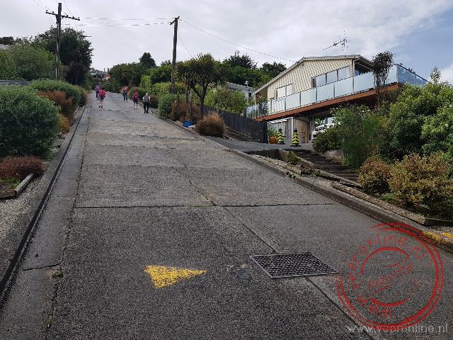
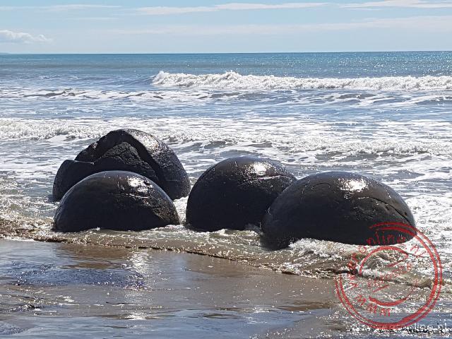
Dag 34 - Monday, January 28, 2019In the northern suburbs of Dunedin lies Baldwin Street. According to the Guinness Book of Records, Baldwin Street is the steepest street in the world, with a gradient of 35 percent. We park the car at the bottom. Dozens of tourists are climbing the street. Some walk backwards—would that make it easier? As I start walking uphill, I immediately feel the steepness. The morning dew even makes the road a bit slippery. How do the residents of the houses on this street normally get home? If you drop something, it immediately ends up a hundred meters below. Bizarre. We follow the coast northwards and pass Moeraki Boulders Beach. Large round stones lie in the bay.
Some have a diameter of two meters. How were these stones formed, and why are they found only here? It is suspected that about 60 million years ago they were worn down by sand and remained at this location. Extraterrestrial spheres or dinosaur eggs seem far less plausible explanations. It’s remarkable how many tourists are here. I haven’t seen so many gathered together anywhere else in New Zealand. Presumably, this is an ideal place for buses to stop briefly. In the next town, Oamaru, there is a sanctuary for the little blue penguins. Normally, you can only see these penguins in the evening, but here it is also possible to observe them during nesting without disturbing them. When we reach the center, we see that no penguin is on the nest—all are out at sea. We can’t see them. The town of Oamaru consists of many old nineteenth-century buildings. Many former warehouses now house art galleries. We stroll along the main street. The streetscape could easily be that of a European town—not surprising, given the strong British influences. We leave the coast and drive inland again. The road winds through rolling countryside.
In the distance, we can already see the mountains of the Mount Cook range. The weather is good, and the peaks are free of clouds. How different it was a week and a half ago, when we were in Franz Josef on the other side of this mountain range. At three o’clock, we arrive in Twizel, a small town on the road to Mount Cook National Park. Here we stay in a comfortable motel. From Twizel, it’s still about an hour’s drive to the park. As soon as we turn onto the road, we see a sign for glacier flights. It turns out to be a scenic flight in a small airplane. The owner says the wind is strong today, but if we don’t mind a bumpy flight, we can go straight away. “Tomorrow should be better,” he adds. “Call me if you want to come along.” Our preference is for a helicopter ice landing on the glacier. A few kilometers further on, there is a sign for Heliflights. A flight is still possible tomorrow at one o’clock. Today, the wind is too strong for a helicopter, but tomorrow looks more favorable, says the staff member.
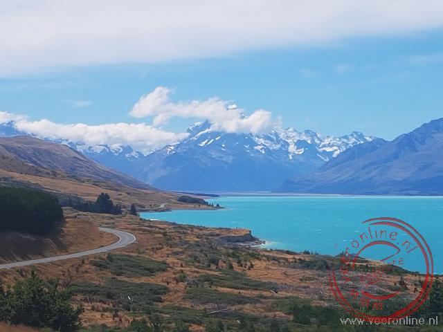
The decision will be made tomorrow morning. We can call at nine o’clock to ask if the flight will take place. We decide to reserve the flight—fingers crossed it works out. We continue driving to Mount Cook. The mountain stands out beautifully against the blue water of Lake Pukaki. We park at the start of the Kea Track, a short walk to a glacier lake. From here, we have views of the glaciers in this area. Most of the mountain peaks are snow-capped. The winner, as always, is New Zealand’s highest mountain: Mount Cook. The mountain gleams in the sun. What a magnificent sight. Hopefully, the Tasman Glacier will look just as spectacular tomorrow, with not too much wind. We drive back to Twizel.
 New Zealand
 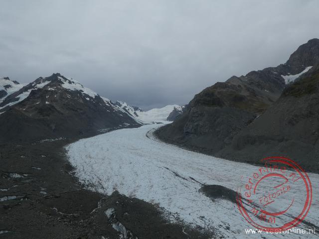 The 24kilometerlong Tasman Glacier
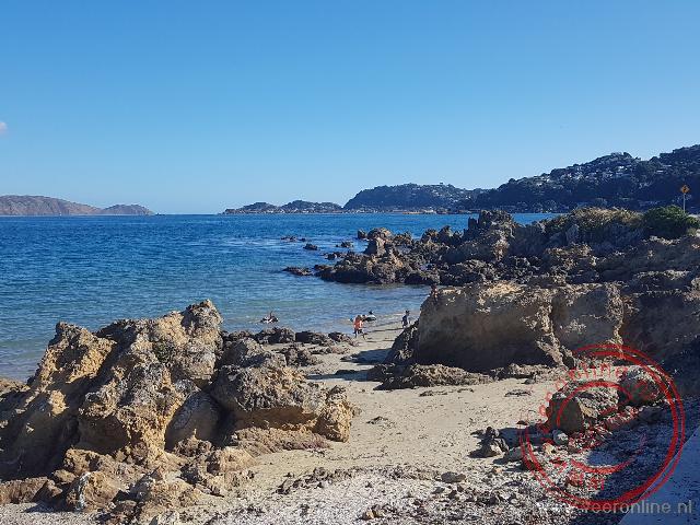 One of the bays around Wellington
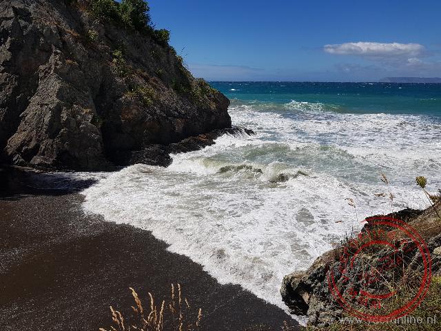 Waves crashing on the small beach at Monkey Bay
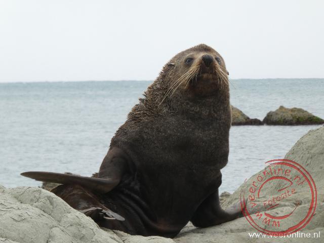 A seal on the rocks near Kaikoura
Travelogue Fiji and New Zealand
Dag 2 | Fiji > The airport of Guangzhou
Dag 3 | Fiji > The hotel is closed
Dag 4 | Fiji > Shopping in Sigatoka
Dag 5 | Fiji > The Viti Levu highlands
Dag 6 | Fiji > New Year's Eve in Fiji
Dag 7 | Fiji > Deep sea fishing
Dag 8 | New Zealand > To New Zealand
Dag 9 | New Zealand > The apartment is already occupied
Dag 10 | New Zealand > Dolphin spotting
Dag 11 | New Zealand > To Cape Reinga
Dag 12 | New Zealand > The Cathedral Cove
Dag 13 | New Zealand > Coromandel Coastal Walkway
Dag 14 | New Zealand > Hot Water Beach
Dag 15 | New Zealand > White Island Volcano
Dag 16 | New Zealand > Thermal park Wai-O-Tapu
Dag 17 | New Zealand > Tongariro Alpine Crossing
Dag 18 | New Zealand > To Wellington
Dag 19 | New Zealand > The Te Papa museum
Dag 20 | New Zealand > Ferry to South Island
Dag 21 | New Zealand > No whale watching trip
Dag 22 | New Zealand > The Marlborough Sounds
Dag 23 | New Zealand > Abel Tasman in Nelson
Dag 24 | New Zealand > Kayaking in Abel Tasman N.P.
Dag 25 | New Zealand > To the Pancake Rocks
Dag 26 | New Zealand > Can we go on the glacier?
Dag 27 | New Zealand > To Queenstown
Dag 28 | New Zealand > Funyak on the Dart River
Dag 29 | New Zealand > Te Anau in Fjordland
Dag 30 | New Zealand > Boat trip Milford Sound
Dag 31 | New Zealand > Waterfalls in the Catlins
Dag 32 | New Zealand > To Dunedin
Dag 33 | New Zealand > Otago Peninsula
Dag 34 | New Zealand > Moeraki Boulders
Dag 35 | New Zealand > Helicopter hike on the glacier
Dag 36 | New Zealand > Lake Tekapo
Dag 37 | New Zealand > Christchurch after the earthquake
Dag 38 | New Zealand > Departure Auckland
Dag 39 | New Zealand > From China to Home