154 countries
(and areas)
 - Azerbaijan
- Bahrain
- Barbados
- Belgium
- Belize
- Benin
- Bhutan
- Bolivia
- Bonaire
- Bosnia and Herzegovina
- Botswana
- Brazil
- British Virgin Islands
- Brunei
- Bulgaria
- Cambodia
- Canada
- Cape Verde
- Chile
- China
- Costa Rica
- Croatia
- Cuba
- Curacao
- Cyprus
- Czech Republic
- Denmark
- Dominica
- Dominican Republic
- Egypt
- El Salvador
- England
- Estonia
- Eswatini (Swaziland)
- Ethiopia
- Fiji
- Finland
- France
- French Guiana
- Georgia
- Germany
- Gibraltar
- Greece
- Grenada
- Guadeloupe
- Guatemala
- Honduras
- Hong Kong
- Hungary
- Iceland
- India
- Indonesia
- Iran
- Ireland
- Israel
- Italy
- Jamaica
- Japan
- Jordan
- Kazakhstan
- Kenya
- Kosovo
- Kuwait
- Kyrgyzstan
- Laos
- Latvia
- Lebanon
- Lesotho
- Liechtenstein
- Lithuania
- Luxembourg
- Macau
- Madagascar
- Malawi
- Malaysia
- Maldives
- Malta
- Martinique
- Mexico
- Moldova
- Monaco
- Mongolia
- Montenegro
- Morocco
- Mozambique
- Namibia
- Nepal
- Netherlands
- New Zealand
- Nicaragua
- North Macedonia
- Northern Ireland
- Norway
- Oman
- Pakistan
- Palestine
- Peru
- Philippines
- Poland
- Portugal
- Qatar
- Republic of Korea
- Romania
- Russia
- Saint Kitts and Nevis
- Saint Lucia
- Saint Martin
- Saint Vincent and the Grenadines
- San Marino
- São Tomé and Principe
- Saudi Arabia
- Scotland
- Senegal
- Serbia
- Singapore
- Sint Maarten
- Slovakia
- Slovenia
- South Africa
- Spain
- Sri Lanka
- Suriname
- Sweden
- Switzerland
- Tajikistan
- Tanzania
- Thailand
- The Gambia
- Tibet
- Togo
- Transnistria
- Trinidad and Tobago
- Tunisia
- Turkey
- Turkmenistan
- Uganda
- United Arab Emirates
- United States
- Uruguay
- Uzbekistan
- Vatican City
- Vietnam
- Wales
- Zambia
- Zanzibar
- Azerbaijan
- Bahrain
- Barbados
- Belgium
- Belize
- Benin
- Bhutan
- Bolivia
- Bonaire
- Bosnia and Herzegovina
- Botswana
- Brazil
- British Virgin Islands
- Brunei
- Bulgaria
- Cambodia
- Canada
- Cape Verde
- Chile
- China
- Costa Rica
- Croatia
- Cuba
- Curacao
- Cyprus
- Czech Republic
- Denmark
- Dominica
- Dominican Republic
- Egypt
- El Salvador
- England
- Estonia
- Eswatini (Swaziland)
- Ethiopia
- Fiji
- Finland
- France
- French Guiana
- Georgia
- Germany
- Gibraltar
- Greece
- Grenada
- Guadeloupe
- Guatemala
- Honduras
- Hong Kong
- Hungary
- Iceland
- India
- Indonesia
- Iran
- Ireland
- Israel
- Italy
- Jamaica
- Japan
- Jordan
- Kazakhstan
- Kenya
- Kosovo
- Kuwait
- Kyrgyzstan
- Laos
- Latvia
- Lebanon
- Lesotho
- Liechtenstein
- Lithuania
- Luxembourg
- Macau
- Madagascar
- Malawi
- Malaysia
- Maldives
- Malta
- Martinique
- Mexico
- Moldova
- Monaco
- Mongolia
- Montenegro
- Morocco
- Mozambique
- Namibia
- Nepal
- Netherlands
- New Zealand
- Nicaragua
- North Macedonia
- Northern Ireland
- Norway
- Oman
- Pakistan
- Palestine
- Peru
- Philippines
- Poland
- Portugal
- Qatar
- Republic of Korea
- Romania
- Russia
- Saint Kitts and Nevis
- Saint Lucia
- Saint Martin
- Saint Vincent and the Grenadines
- San Marino
- São Tomé and Principe
- Saudi Arabia
- Scotland
- Senegal
- Serbia
- Singapore
- Sint Maarten
- Slovakia
- Slovenia
- South Africa
- Spain
- Sri Lanka
- Suriname
- Sweden
- Switzerland
- Tajikistan
- Tanzania
- Thailand
- The Gambia
- Tibet
- Togo
- Transnistria
- Trinidad and Tobago
- Tunisia
- Turkey
- Turkmenistan
- Uganda
- United Arab Emirates
- United States
- Uruguay
- Uzbekistan
- Vatican City
- Vietnam
- Wales
- Zambia
- Zanzibar


Copyright 2004 - 2026
Veeronline.nl Travel Adventures
Home > Andorra > The Mountain State of Andorra > Travelogue day 2
Travelogue The Mountain State of Andorra
August 310 2013 (8 days)
Andorra > The Madriu-Claror-Perafita valley
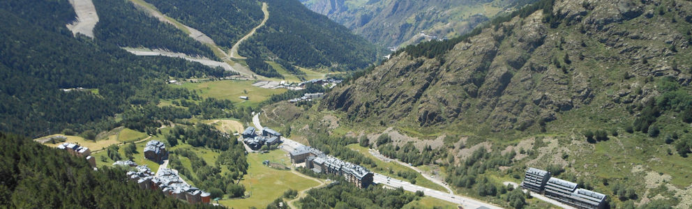
Dag 2 - Sunday, August 4, 2013Around half past nine in the morning, when I leave the hotel for the first hike, the bus is already waiting. The bus driver is in a discussion with two traffic controllers. He is not allowed to park the bus in front of the hotel. I quickly get on so we can depart. The bus drives back toward the capital, Andorra la Vella. Just before the city, the driver turns left toward the Madriu-Claror-Perafita valley.

The hike begins at the small village of Sant Miquel d’Engolasters. I get off and follow a section of the long-distance trail GR7. The path is marked with white-and-red signs. The Madriu-Claror-Perafita valley is a UNESCO-protected natural area. It was shaped by glaciers, and ancient Roman remnants have been found here. As I walk up the path paved with rocks, I wonder if the Romans built this path. Roman roads were often wider to accommodate horse-drawn carts. The path steadily climbs, and I quickly gain altitude. I watch the village of Sant Miquel d’Engolasters shrink in the valley below. The weather today is beautiful. The deep blue sky contrasts strikingly with the green forested mountains. I continue climbing under the cover of the trees. After about an hour and a half, the path levels out. It also stops running over large rocks, which gives me more time to look around without tripping. Around lunchtime, I arrive at a refugio—a stone house in the middle of the valley.

I fill my water bottle at the spring. Due to the warm weather, I have already drunk a lot of water. I sit on the veranda and open my lunch. This morning, I could either buy a lunch pack at the supermarket or order one from the hotel. I chose the latter. Inside the foil is a delicious sandwich with tuna and anchovies—a perfect choice. After the lunch break, I walk back a short distance to take a right at the junction. I follow the Cami al llac d’Engolasters toward the lake of the same name. The route runs along a mountainside above a steep drop. Because of many rockfalls, the path also passes over boulders. Fortunately, the route is downhill, making it easy to walk. Just before a tunnel through the mountain, there is a viewpoint on the left side. I climb the stairs, and from the platform, I have a wide view over Andorra la Vella. The capital lies in the valley below, squeezed between the mountains. From this vantage point, it’s clear that the city cannot expand further, explaining the growing number of high-rise buildings. I descend from the platform and continue my route.

As I get closer to Engolasters Lake, the path improves. The final stretch is even two meters wide and has a wooden railing. It’s clear this section sees many day visitors. Unsurprisingly, the parking lot near the lake is full of cars from recreational visitors. For me, this is the end of the walk. It’s half past three—a perfect time to order a beer on a terrace. Satisfied, I look back on a wonderful hike. Before returning to the hotel, I visit a small old church along the roadside. The caretaker of the Església de Sant Miquel d’Engolasters tells me about the stone structure and its 17-meter-high tower. He also explains that the frescoes inside were once removed, and the current paintings are replicas. I thank him for the explanation. The bus takes about half an hour to return to Soldeu. In the evening, I eat fish paella and gazpacho (cold soup) at a restaurant on the main road through Soldeu.
 Andorra
  The clear mountain lake Estany Cabana Sorda at 2300 meters altitude
 The barren landscape above the treeline
 A waterfall in the mountains
 One of the many shopping streets in Andorra la Vella
Travelogue The Mountain State of Andorra
Dag 2 | Andorra > The Madriu-Claror-Perafita valley
Dag 3 | Andorra > From Ransol to Canillo
Dag 4 | Andorra > The capital Andorra la Vella
Dag 5 | Andorra > Rain in Andorra
Dag 6 | Andorra > Between mountain lakes and peaks
Dag 7 | Andorra > Walking in the snow
Dag 8 | Andorra > In the dark through Andorra